Editorial Quick Take
The art of cartography is one that has undergone constant revision. Mapmakers have sometimes gotten things wrong for centuries at a time. Public contradictions abound. Yet we never stop making maps.
Perhaps this is because cartography is driven by two simultaneous human needs. One is the enduring need to know, but the other is the more practical need to get somewhere. Maps that primarily address the latter need are called itineraries.
In the first century BC, Augustus Caesar commissioned his son-in-law Marcus Agrippa to survey the Roman world. The task took twenty years and resulted in mile markers along endless Roman roads and a master map, carved into a magnificent marble circle set up near the forum. Agrippa’s map was then reproduced and embellished over the years.
Though the original was lost, a curious map came to light in the sixteenth century from the collection of a German town clerk, Konrad Peutinger. Scholars believe that Peutinger’s map (known as the Peutinger Table) is an eleventh- or twelfth-century copy of a third-century document ultimately owing its existence to Marcus Agrippa’s work.
The Peutinger Table maps the world from Britain to the Ganges. The scroll on which it is written is twenty-eight feet long and just sixteen inches wide! As the dimensions suggest, the map is not complete, but follows the routes of main roads, mapped as straight lines. Towns are indicated by a house, cities by a medallion. Spas, forts, and bathing sites are also noted, along with the great forests of Germany and Syria.
The geography fails at points. (The Nile flows East-West, for instance). But the basic orientation of cities, towns, and the distances between them would certainly have served travelers well.
A similar document, the fourth-century Bordeaux-Jerusalem Itinerary is a travelers’ guide, a map in prose. The itinerary is a set of written directions from France to the Holy Land gathered by an anonymous pilgrim. The pilgrim marks the miles between changing stations for the horses (mutationes) and rest-stops (mansiones) and records notes such as, “There is a place above the river, a little hill in that shore, where Elijah was seized up into heaven.”
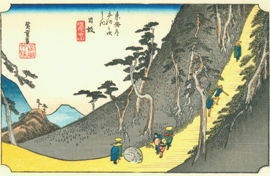
A notable line of itineraries also surfaced in Japan during the Edo period (1603-1868). Many of these describe the Tōkaidō, the journey by land and sea from the contemporary capital of Tokyo to the ancient capital of Kyoto and on to Nagasaki. During that time feudal lords were required to spend every second year in Edo. To provide for this, mapmakers began making woodcuts and scrolls. Some were pocket-sized but some approached the size of the Peutinger Table.
While the Japanese maps served the same function as their European cousins, they were also intended to evoke a sense of place and the spirit of travel and the land. They portrayed travelers, inns, hot springs, historic sites, and landscape views drawn by ukiyo-e artists such as Hishikawa Moronobu and Katsushika Hokusai.
Nor is the itinerary consigned to the distant past. With the advent of the automobile, Americans were able to venture further than ever before and there was a sudden need for maps. Between about 1895-1915 the answer was to be found in an itinerary. While these often contained rudimentary maps, they were closer to the Bordeaux-Jerusalem Itinerary of the third century, relying on local eyewitness instructions such as: “Over the railroad tracks, turn left at the first red barn.”
By 1920 the burgeoning highway system had made such itineraries impractical. Drivers turned instead to what we would recognize as contemporary road maps. Though they have less local color, the road map can simply convey much more data on a single page. This development led to a century of mapmaking dominated by the likes of Rand McNally.
However, technology has given rise to another shift in cartography, and we are entering another phase of itinerary-dominated map culture. How many consult a road atlas any more? Look to Google Maps for context and not just a route to the grocery store in a new town? These days the itineraries need not even be visual. They can be audible. “In six hundred feet, keep right.” If we simply need to know how we can get from where we are to where we are going, Siri can tell us that.
But what about that other, perhaps even deeper, need? Can cartography still address that enduring need to know?
Header image: “Nissaka-shuku, the 25th station on the Tōkaidō,” Hiroshige, 1833/34 (public domain).
For the rest of Hiroshige’s 53 stations, click here.


6 Comments
Nancy Grams
We have always been a “need to see” map family. Thank you for a fascinating history on cartography!
Marge Connolly
Maps that fulfill the “need to know”: I am reminded of my various editions of Dante’s Inferno, each with maps that envision the circles of hell; of the maps plotting out journeys in the Odyssey; Ernest H. Shepard’s map of “The Wild Wood and Surrounding Country” in The Wind in the Willows; and most beloved of all, Christopher Tolkien’s maps to complement his father’s Lord of the Rings. If a world is real, there is a human desire to map it. Why we feel the need is worth pondering.
Jon Balsbaugh
I love your thoughts on this, Marge. I seems as if there is even a metaphorical significance here. “If a world is real, there is a human desire to map it.” We are world mappers as well as world shapers.
Aaron Weisel
Had to share this: https://www.youtube.com/watch?v=92RE8FME8WM (skip to 9:09)
Does the desire for a map of any given territory respond only to a desire to know? Or does it also inevitably lead to a desire for a kind of dominion over a place? That, by knowing the lay of a land, we grasp for a (however illusory) sense of control over it? Maybe I’m getting simultaneously a tad philosophically overwrought and superficially wanderlusty here, but there’s something to be said for allowing our entry into a new land dominate us, and take us up into it glorious mystery. This piece got me thinking about distinguishing between, but not entirely separating, the desire to know and the desire for power over of any given object.
Maps are so bound up with the most compelling narratives.
Love the subtle distinction between itinerary and mere maps. Very Thomistic 🙂 And the fact that this piece draws from all over the world (especially in a period of Japan corresponding to the Renaissance in the West) feels very very fitting, considering the points being made and the questions evoked.
Pingback:
Pingback: